
Tégama Gr
Type Locality and Naming
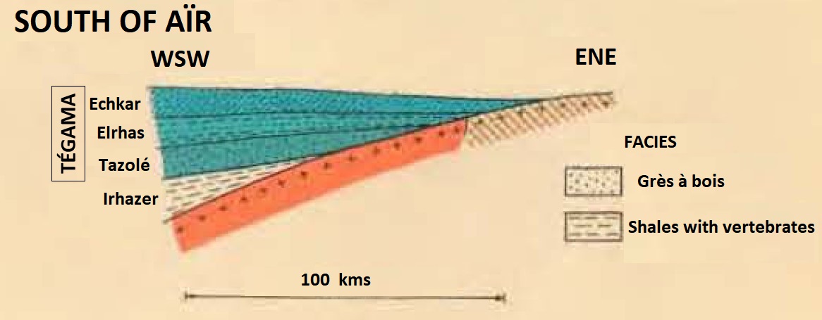
Reference section is the Gadoufaoua paleontological site (dinosaur fossils). Chudeau, 1907 & 1909. This Group is part of the Continental Intercalaire. Today, this group is subdivided into the Tazolé Fm (bottom), Elrhaz Fm (middle) and Echkar Fm (top).
References: Chudeau, 1907 & 1909; Joulia, 1951; Boureau, 1953; Lapparent, 1955; Faure et al., 1956, emend. Greigert & Pougnet, 1967; Joulia, 1958; Molinas, 1965; Faure, 1966; Greigert, 1967; Bigotte & Obelianne, 1968; Taquet, 1970 & 1976; Fabre et al., 1983; Dikouma, 1990; Kogbe, 1991.
Synonym: Tegama Gr, "Grès et argiles du Tégama". Equivalent(s): Téfidet Gr. Also, in the Kandi Sub-Basin of Benin and Nigeria, petrified woods have been found in the Lower Cretaceous Sendé Fm , which is similar to those found in the Tégama Gr and Téfidet Gr (Konaté, 1996, 2003, 2006).
Lithology and Thickness
The Tégama Group is a continental episode with sandy characteristics. However, some variations in facies in certain regions give it a shaly appearance. The group extends through the north and the center of the basin as far south as the 15° N latitude, where boreholes have penetrated it. It is characterized by sediments that are dominantly sandy with shaly or calcareous intercalations (Bellion, 1987, 1989). Today, this group is subdivided into the Tazolé Fm (bottom), Elrhaz Fm (middle) and Echkar Fm (top) (Figure in regional extent) (see these terms for their definition and details).
Molinas (1965) and Bigotte & Obelianne (1968) give a summary log of this group for the Tim Mersoï Sub-Basin, west of the Aïr as well as the southwest area. Molinas (1965) also describes the Group southeast of the Aïr within the Gadoufaoua deposit. The stratigraphic terms they used, now obsolete, are described below and are also correlated to their newer assignation within the group (Echkar, Elrhaz and Tazolé).
WEST: The group is practically represented by brown to red clays, sandstones intercalated with marls and thin channels of fine calcite sandstone. Only a sandstone bed horizon (called *"T14") can be followed towards the West with a thickness of 5 to 10 m maximum (Molinas, 1965; Bigotte & Obelianne, 1968).
*TEG 1: It begins with a thin, coarse sandstone level with clay pebbles, quartz granules and red chert debris. This bed has been observed in places east of In Allaren.
*TEG 2: At its base, it begins with sandstone with fossilized wood (level *T14 which can be correlated with the Amerzou) alternating with clay. Then purple, red or gray, sandy clays, interspersed with small channels of fine sandstone, intraformational conglomerates, and cherty limestone.
SOUTHWEST (Molinas, 1965; Bigotte & Obelianne, 1968) [The "*" = discontinued nomenclature]
*Terzikasan: Apart from a recurring shaley facies at the base, which is very localized, the whole is characterized by a significant deposit of a coarse to very coarse, red to yellow, wood-like sandstone. Above, alternate levels of medium clayey sandstone, with calcite lumps, sometimes variegated, and purple sandstone clays. The Terzikazan (0-127 m), defined in drilling (because beveling to the NE it does not outcrop), comprises two units:
- The first is formed by a succession of sequences, 10 to 20 m thick, of coarse to fine sandstone, with a scanty clay matrix, rare feldspars, pyrite and carbonaceous debris and gray-green siltstones and silty shales.
- In the second, overlying, the shaly terms are more developed and more or less calcareous; pyrite and coal are rarer.
*Amezrou (67 m): It is a mostly sandstone assemblage, in the form of coarse ocher sandstone, in thick beds with wood, topped with medium to fine clay sandstone, rich in heavy minerals and silty clay with quartz grains. It ends with a thin layer of sporadic clay.
*Anyeli-Tin Sakan: It is a coarse shaly sandstone, poorly cemented, and not very clear motley character. Some silicified woods are visible. The whole ends with a high level of clay.
*Girmaga: The whole has a constant motley character. They are coarse to medium-sized, shaly sandstones with numerous shaly levels, sometimes showing thin levels of chert. It breaks down into two relatively regular sandstone-shale units.
*Mohra: Alternating coarse ocher sandstone, wood at the base and black or multicolored shales. At the top, the sandstones become micaceous. The shales fade in shades of gray, green, and yellow, and show pockets of sand, manganese nodules and limonite chunks.
*Tim Anasin: The whole consists of red to coarse white sandstones, poorly cemented, with numerous silicified woods. Above, the sandstones become more shaly, with green and purple shale patches. The unit ends in gray micaceous shales with ocher sandstone channels.
*Ekisman: It is characterized by its motley purple and white color. The sandstones are coarse, little feldspathic, alternating with variegated shales, sometimes with the presence of chert.
*Borak: Shales with channel sandstones. The more significant presence of clastic sediments infers a likely braided river influence.
*Aïn Toufayen (above the Tégama Group): These are ocher, coarse, feldspathic sandstones alternated with shales often variegated red and green or purple and green. These sandstones pass laterally to motley shales, interspersed with sandy beds, calcite lumps and intraformational conglomerates with reptile bone debris.
SOUTHEAST (Molinas, 1965)
The “GAD” system below (“GAD” = Gadoufaoua) was elaborated by the C.E.A in 1965.
GAD 1: At the base, a shaly sandstone unit made up of coarse white sandstones, poorly developed, kaolinitic, with large healthy feldspars, alternated with beds of purple and gray clays. Presence of calcitic lumps, bone debris and silicified wood. At the top, a sandstone unit, with gravel or quartz pebbles, distributed in regular beds or more rarely scattered. The shales, rare, are gray or green.
GAD 2: It is a unit with shaly sandstones and variegated characters. The sandstones are coarse to conglomeratic at the base, very shaly, gray, white or purple, and little feldspathic. The shales are in the form of lenses, rarely in continuous beds. The sandstone-shale separation is not well demarcated.
GAD 3: It begins with ocher, coarse, non-shaly sandstones with deltaic characteristics or with coarse sandstones with variegated, fluvial episodes. Above comes a large level of red to purple shale, with coarse sandstone channels, ocher, and scattered pebbles. The second episode of coarse, channeling sandstone then appears in association with purple shales. The whole ends with thin channels of fine sandstones with calcitic lumps.
GAD 4: Gray shaly sandstone unit. Coarse sandstones, gray-beige conglomerates, silicified wood, and pyrite with some hematite content are at the base. Calcitic slabs or balls are frequent. Above are coarse purple or white sandstones. These sandstones pass laterally to channel shales of medium to fine sandstone, calcitic.
GAD 5: Shale level, monotonous, beginning with a thin level of ocher sandstone, feldspathic, with black spots and scattered quartz pebbles and wood debris. It continues with variegated, slightly marly shales and a channeling episode of large coarse, feldspathic sandstone. At the top, many small channels of fine calcite sandstone alternate with shales. The level is remarkable for the abundance of reptile bones (crocodilians and dinosaurians) and fish bones.
GAD 6: It is a series of purple sandstones at the base, coarse, feldspathic, not very shaly, having undergone in place a phenomenon of discoloration, giving it on the surface an ocher beige appearance. Ferruginous joints are numerous. These sandstones are accompanied by fossilized wood within two levels. The unit ends in gray shales with beige sandstone channels.
GAD 7: It begins with a level of beige sandstone with wood forming large channels. Above are variegated, shaly, coarse sandstone with frequent intercalations of equally variegated shale beds; the whole ends in channels with coarse detrital elements.
GAD 8: It is a group of coarse blue-gray, ocher-beige, slightly feldspathic sandstones with scattered quartz pebbles, ferruginous wood, and crusts. These sandstones are surmounted by white to pale green or variegated shales, with sandstone channels, with some rare calcite levels. It ends with a level of white shale with fine sandstone channels, small levels of limestone and debris of reptile bones.
*IN ASSAMED (above the Tégama Group): It is the transition between the Tégama Continental and the marine levels of the Upper Cenomanian. At the base, there are deltaic sediments accompanied by fossil woods. Above, are several successions of yellow sandstone lenses ending in sandy shales and hard ripple-mark levels. The top, made up of red and green variegated clays, passes continuously to the gypsiferous gray clays of the Marine Cenomanian (The top of this unit can be attributed to the Béréré Formation of the Upper Cenomanian).
Thickness: 680 m in the southeast, 520 m in the southwest and 500 m in the west of the Aïr (Molinas, 1965)
Relationships and Distribution
Lower contact
Unconformably overlies the Tiouraren Fm (Irhazer Gr)
Upper contact
Overlain by the Farak Fm
GeoJSON
Fossils
Rich in silicified wood/trunks (Dadoxylon; Boureau (1953)) associated with skeletons of reptiles (Lapparent, 1955), Sauropods, Theropods (Megalosaurus), Chelonians, crocodiles, fish (Onchopristis, Platyspondylus, Lepidotes, Ceratodus) of Lamellibranchs (Unio, Cyrena) and remains of dinosaurians. Taquet (1976) described the fauna of the Gadoufaoua dinosaur site, including the Iguanodontid Ouranosaurus nigeriensis Taquet.
Age
Depositional setting
Fluviatile and lacustrine deposits occurred within broad valleys and marshland under humid tropical and semi-arid conditions (Kogbe (1991)). The channels of these rivers can be the site of uranium concentrations of secondary importance.
Additional Information